Pulau Sumba adalah bagian dari Kepulauan Sunda Kecil yang secara administratif berada di Provinsi Nusa Tenggara Timur. Secara geologis pulau seluas 1,1 juta hektar ini terdiri dari batuan kapur dan campuran tanah liat yang kurang mampu menahan air. Posisi geografisnya menjadikan iklim di Sumba tipikal kawasan ini kering dengan curah hujan yang bergantung pada sistem angin muson dan angin pasat. Karena tidak memiliki gunung berapi, tanah di Sumba tidak memiliki sumber kesuburan vulkanis yang tercermin dari lapisan atas tanahnya relatif tipis dan mudah tergerus erosi.
Di Bentang Alam Sumba Bagian Tengah (BA-SBT), elevasi wilayah mulai dari permukaan laut hingga 950 mdpl dan tertinggi di puncak Wanggameti dengan ketinggian 1.200 mdpl. Mosaik BA-SBT meliputi ekosistem pesisir, padang rumput sabana yang didominasi oleh hamparan dataran yang berbukit yang terlihat sangat kering bahkan tandus pada musim kering. Hari berhujan dalam setahun terbatas dengan volume kurang dari 1.500 mm/tahun.
Iklim kering yang terdapat di Sumba serta kondisi geofisik yang kurang mendukung ketersediaan air menjadi indikasi pentingnya pemeliharaan daerah aliran sungai (DAS) dan ekosistem riparian. Di BA-SBT terdapat 17 DAS yang bermuara ke Selat Sumba dan 15 DAS yang bermuara ke Samudera Hindia dari keseluruhan 92 DAS di Sumba; dengan kata lain, BA-SBT yang wilayahnya mencakup 24% dari luas pulau, menyimpan 35% DAS di Sumba. Hal ini menunjukkan proporsi dan peran signifikan BA-SBT untuk pengelolaan sumber daya air.
Ekosistem yang mendukung fungsi layanan alam seperti hutan sangat terbatas, wilayahnya tersisa hanya sekitar 6% pada dekade 1990-an. Padahal, keberadaan ekosistem hutan kering primer dan sekunder juga merupakan tempat masyarakat Sumba melaksanakan berbagai aktivitas seperti pelaksanaan budaya atau ritual adat, perburuan satwa liar seperti babi hutan, sumber kayu bahan bangunan rumah, dan sumber jenis kayu yang dikeramatkan oleh penganut kepercayaan tradisional marapu. Kawasan Taman Nasional Manupeu Tanah Daru yang terletak di selatan BA-SBT merupakan salah satu hamparan yang memiliki tutupan hutan alam terluas di Sumba dan berperan sebagai pengikat karbon dan penyimpan cadangan air tanah bagi 31 desa di sekitarnya.
Masyarakat Sumba secara tradisional dan hingga kini umumnya adalah petani-peternak; mempraktikkan bertani sekaligus beternak dalam kehidupan sehari-hari. Meskipun iklimnya kering, sistem wanatani berkembang dengan menanam tanaman umur panjang seperti kelapa, kemiri dan jambu mente di hamparan yang lebih berlereng, sementara di hamparan yang lebih datar didominasi oleh tanaman musiman seperti jagung, padi dan ubi kayu. Sistem sengkedan untuk menanam padi pada lereng terjal jarang ditemukan di sini, dan sistem irigasi belum banyak digunakan karena petani lebih mengandalkan sistem tadah hujan.
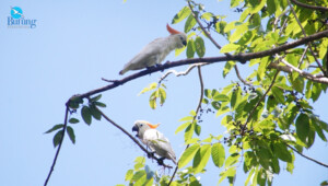
Sumba memiliki posisi penting dalam hal keragaman hayati global. Kekhasan ekosistem dan jenis hidupan liar telah menempatkan Pulau Sumba sebagai satu dari 23 Daerah Burung Endemik di Indonesia. Julang sumba, walik rawamanu dan delapan jenis burung lainnya tidak ditemukan di bagian bumi manapun kecuali di Sumba. Tercatat 24 Daerah Penting bagi Keragaman Hayati (Key Biodiversity Area) ada di pulau ini.